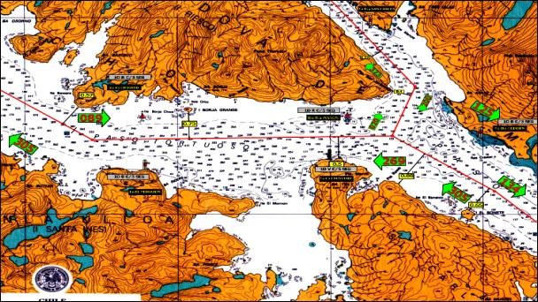
5. Paso Tortuoso
The total extension of this passage, between Punta San Jerónimo and Cabo Quod, is 6.3 nautical miles, with its greatest useful width being 0.9 nautical miles between Cabo Crosstide and Roca Anson.
In this passage, the north coast has two shoals properly marked by buoys. These are Roca Anson and Roca Crooked, which are located 4 cables to the north of the navigation track.
The difficulty of this passage is represented by the crosscurrents, which go up or down Canal Jerónimo, and affect the vessel transversely up until the entry or exit of Paso Inglés, near Isla Rupert. In the proximity of Cabo Crosstide, as well as in Paso Inglés, the currents reach up to 3.5 knots and sometimes more during ebb tide. This is due to the fact that in this area the current of the Strait of Magellan meets the current of Canal Jerónimo. In general, the current feels more intensely in the direction of the prevailing winds, that is, from NW to SE.
Vessels with great draught and length can wait for the slack current to occur in Canal Jerónimo, in order to navigate Paso Tortuoso with more tranquility and safety. The experience of the Channel Pilots currently makes it possible to navigate this passage with large vessels, up to 21.3 m draught, at any time.
Special instructions for the navigation of Paso Tortuoso:
Considering that vessels’ size has increased considerably, making it difficult for them to maneuver quickly in order to comply with the International Regulations for Preventing Collisions at Sea while crossing Paso Tortuoso, it is arranged to:
a) Inform the corresponding Maritime Traffic Control Station (Faro Evangelistas, Bahía Félix, Punta Arenas or Punta Delgada) of the estimated passing time through Paso Tortuoso. When a Channel Pilot is on board, they perform this assignment.
b) In the passage itself, there is the Maritime Traffic Control Station “Tortuoso”, which should be called to report navigation in the area and to report the next control points in the Strait of Magellan towards the vessel's destination. When a Channel Pilots are on board, they perform this task.
c) Permanently stand by on the international VHF safety frequencies, Channel 16 and Channel 70. On channel 16, broadcast a safety message, in Spanish and then in English, one hour before crossing Cabo Crosstide, informing: vessel's name, current position, crossing direction and estimated time of crossing. This same information shall be repeated every 15 minutes until the end of the crossing.
d) Navigate to starboard of the channel axis, whenever possible and without affecting the safety of the vessel.
e) Grant right of way to the transit of VLCC type super vessels, or vessels with a length over 200 m, informed by safety signals from the National Maritime Authority or reported by the Maritime Traffic Control Stations in the Strait of Magellan.
f) Keep the navigation lights permanently on.