Pilotage in the strait of Magellan and Chilean channels and fjords
Provisions, regulations and general information on pilotage in Chile
1. Geographic description
Chile is located in the extreme southwest of South America and has 2,400 nautical miles of coastline. South of latitude 41º 45' South, there are 1,095 nautical miles of channels, straits, narrows, and fjords. This provides inland waters sheltered from bad weather and storms common in the southeast Pacific and suitable for the safe navigation of all types of vessels. This area of inland waters, composed of channels, straits, narrows and fjords, is divided into three geographical areas:
|
Area |
|
|
Chiloé and Aysén area |
From latitude 41º 45’ South (Chacao Channel/Ancud) to 47º 00’ South (Golfo de Penas). |
|
Patagonian area |
From 47º 00’ South (Golfo de Penas) to Magellan Strait. |
|
Fuegian area |
From the Strait of Magellan to Cape Horn, including Isla Tierra del Fuego and the Fuegian channels. This last sheltered region is the most used passage to reach Antarctica. |
2. Weather
The characteristics of the southernmost area of Chile, from latitude 40º S to the south, are sudden changes in wind and sea conditions throughout the year. It is said that all four seasons can be experienced in the same day.
Low pressures and associated bad weather fronts move from W to E and SE, intensifying as they increase in southern latitude, generating storms with strong NW winds and waves, mainly between March and August (Autumn and Winter in the Southern Hemisphere).
In the oceanic area, there are heavy swells that normally produce a double swell, difficult to differentiate; from the SW as swell and from the NW as wind waves.
The areas of Chiloé and Aysén are rainy, mainly in winter. On the other hand, during summer (December to March), weather is milder and sunny days are more frequent; however, this does not eliminate the possibility of showers.
Winds from the south, associated with high-pressure systems, are strong, and commonly occur during spring and summer (September to March). In the Patagonian area, summer is known as the windy season. Both the Patagonian and Fuegian areas are cold and rainy throughout the year. Winter is colder and it snows mainly from May to August.
The large network of inland channels, straits and fjords, from the Chacao Channel (latitude 41° 45'S) to Cape Horn (latitude 56°S), has safe navigation routes, with deep and clean waters, where the strong winds of oceanic storms are mitigated by the high peaks of the mountain range, and the swell disappears. During the thawing season (spring), it is possible to find small pieces of ice in some channels, which must be navigated with caution.
General Maritime Forecast; Surface Chart; Wind, Wave and Surface 24-hour Forecast Chart, and Satellite Imagery at: www.directemar.cl-meteorología
3.General regulations
Navigators passing through Chilean channels, straits and fjords must comply with the provisions of the Chilean National Maritime Authority (Directorate General of the Maritime Territory and Merchant Marine - www.directemar.cl), and the information provided by the Hydrographic and Oceanographic Service of the Chilean Navy on their web page www.shoa.cl. In this link, there are corrections to current cartography and Urgent News to Navigators.
Chile has 12 miles of Territorial Waters, in addition to 188 miles of Exclusive Economic Zone. In territorial waters, all foreign vessels must fly the flag of their country of origin, together with the Chilean flag, from sunrise to sunset. Moreover, the signal flag "Hotel" must be hoisted when pilots are on board, and the signal flag "Bravo" when carrying dangerous goods.
Vessels must comply with all Chilean and international rules and regulations, such as SOLAS, COLREG and MARPOL, including IMO and ISM resolutions and standards, and all those especially related to the protection of human life at sea and the protection of the marine environment. In inland waters, it is strictly forbidden to dump waste, oil or any kind of oily or polluted liquid.
Ballast exchange and the discharge of residual "grey water" shall comply with MARPOL regulations. The ships that have a WTP facility (Water Treatment Plant), previously authorized by the National Maritime Authority, may discharge grey water 4 miles offshore, but under no circumstances discharge in inland waters with a distance to the coast greater than 4 nautical miles. Compliance with pollution prevention regulations is requested.
4. Pilotage policy
The Pilotage Service depends on the National Maritime Authority, as established in the Navigation Law of the Republic of Chile of 21 May 1978.
Pilotage is compulsory for navigation in inland waters between the Chacao Channel and Cape Horn. Channel Pilots will normally be transfered at the Pilot Stations mentioned below. However, Maritime Agencies may request embarkation or disembarkation at any of the ports north of the Chacao Channel. Pilot assistance can also be requested for Antarctic navigation.
Maritime Agencies must send the pilotage request to the Pilotage Service office in Valparaiso (See paragraph 9.- letter h. - ADDRESS IN VALPARAISO - CHILE), at least 48 hours in advance for ships departing from the Valparaiso Region or the port of Los Vilos, and not less than 72 hours in advance for vessels departing from other transfer stations and ports outside the Valparaiso Region or from abroad. Longer notice should be considered when dealing with ports with low frequency of land or air transportation for the arrival of pilots to the embarkation point. Two Channel Pilots shall provide such assistance. The arrival time (ETA) at the Pilot Station must be updated daily to avoid extra expenses or delays.
Channel Pilots are retired Chilean Navy and Merchant Marine officers, with experience commanding vessels. On board, they equal the Master, therefore must be provided with individual cabins with bathroom in the officers' quarters and have free access to the corresponding recreational areas. They must have all the resources necessary for their work on board, especially those related to official communications, which shall be free of charge for pilots.
To enter the straits and channels within the Compulsory Pilotage Area, Channel Pilots shall normally begin their pilotage assistance duties 1 hour before and at a distance that provides safety to the vessel when navigating inland waters. In the same way, assistance will cease when leaving inland waters (open sea), at a safe distance and time that ensures the vessel is no longer in channels.
When navigating inland waters, channels, straits and fjords, Channel Pilots have 5-hour watches (except from 08:00 to 12:00).
To complement this, see Admiralty List of Radio Signals; Pilot Services, Vessel Traffic Services and Port Operations; NP 286 (7), Vol. 6, 1st. Edition, 2020 (2), Pages "CHILE" (85 to 120).
5. Pilot stations
The following transfer stations are available for embarking and disembarking Channel Pilots:
| Ancud (1) | (Lat.: 41° 47.67’ S, Long.: 073° 50.435’ W); entry or exit of Chacao Channel. |
| Laitec (1) | (Lat.: 43º 20.0' S, Long.: 073º 36.0' W); to the South of Isla de Chiloé. Pilot Transfer Zone. |
| Bahía Posesión (2) | (Lat.: 52º 22.75' S, Long.: 068º 58.63' W); eastern entry/exit of the Strait of Magellan. For all vessels, in good weather conditions. Pilot Transfer Zone. In bad weather conditions, transfer will take place through Punta Delgada Pilot Station Control Centre (Lat.: 52º 28.17’ S, Long.: 069º 31.43’ W). In this case, Pilots will control safe navigation of the vessel by radar from the VTS in the Pilot Station. |
| Punta Arenas (2) | (Lat.: 53° 10.5’ S, Long.: 070° 54.5’ W); Strait of Magellan. |
| Cape Horn (3) | (Lat.: 55º 56.58' S, Long.: 067º 12.56' W); Pilot Transfer Zone. |
| Paso Richmond (3) | (Lat.: 55º 20.85' S, Long.: 066º 40.88' W); south of Caleta las Casas (Isla Nueva). Pilot Transfer Zone. |
| East Beagle Channel (3) | (Lat.: 55º 07.95' S, Long.: 066º 32.98' W); north of Punta Waller or Caleta Carlos (Isla Nueva). Pilot Transfer Zone. |
| Bahía Cook | (Lat.: 55° 10.17' S, Long.: 070° 12.61' W); Pilot Transfer Zone. |
NOTE: Notwithstanding the abovementioned Transfer Stations, vessels can embark and disembark Channel Pilots at departure or arrival in port according to their requirements and in compliance with the Pilotage Policy in Section 4. To enter the pilot boarding areas of Ancud, Laitec and Bahía Posesión, the following Waypoints are recommended:
| Ancud | Latitude (S) | Longitude (W) | Name WP |
| 41°34.93 | 074°02.49 | Punta Quillagua | |
| 41°40.23 | 074°00.34 | Golfo Coronados | |
| 41°45.86 | 073°51.52 | Faro Corona | |
| 41°47.67 | 073°50.435 | Ancud |
| Laitec | Latitude (S) | Longitude (W) | Name WP |
| 43°16.45 | 074°51.38 | Cabo Quilan | |
| 43°34.94 | 074°24.49 | Isla Guafo | |
| 43°35.00 | 073°47.00 | Rocas Canoitad | |
| 43°27.00 | 073°36.00 | Laitec Sur | |
| 43°20.50 | 073°36.00 | Laitec |
| Bahía Posesión | Latitude (S) | Longitude (W) | Name WP |
| 52°28.17 | 069°31.43 | Punta Delgada | |
| 52°21.21 | 069°18.77 | Banco Narrow | |
| 52°21.20 | 069°07.80 | Bahía Posesión | |
| 52°22.75 | 068°58.63 | Pilot Posesion | |
| 52°30.53 | 068°30.40 | Punta Dungeness | |
| 52°40.59 | 068°09.97 | Atlántico |
6. Pilotage fees
Pilotage fees are set depending on the Gross Tonnage (GRT) of the vessel. They are established in the Regulations of Rates and Fees of the Directorate General of the Maritime Territory and Merchant Marine, approved by Supreme Decree No. 427 of 26 June 1979. They are updated annually according to the U.S. CPI and are of public access (See www.directemar.cl - Publications -Maritime Regulations - Regulations of Rates and Fees).
Maritime Agencies are in charge of embarking and disembarking Channel Pilots with their pilot boats, and for exception, due not exist pilot boats, in Bahía Cook, Cape Horn and Paso Richmond, the pilot transference is usually carried out with boats of the National Maritime Authority.
The Tug and Launch Service for mooring in port is provided by the corresponding Maritime Agency. The "Standard Fee" for the pilotage service in the channel area, for a continuous navigation between Bahía Ancud (Chacao Channel) and Bahía Posesión (eastern entry of the Strait of Magellan) within a period of 120 hours, with 2 Channel Pilots, is as follows:
| GROSS TONNAGE (GRT) | FEE | |
| FROM | TO | USD |
| 2.000 | 3.836,04 | |
| 2.000 | 4.000 | 6.552,16 |
| 4.000 | 6.000 | 8.948,77 |
| 6.000 | 8.000 | 10.226,95 |
| 8.000 | 10.000 | 11.505,15 |
| 10.000 | 12.000 | 12.623,55 |
| 12.000 | 14.000 | 13.742,36 |
| 14.000 | 16.000 | 14.700,58 |
| 16.000 | 18.000 | 15.820,50 |
| 18.000 | 20.000 | 16.779,12 |
| 20.000 | 22.000 | 17.578,00 |
| 22.000 | 24.000 | 18.378,36 |
| 24.000 | 26.000 | 19.335,51 |
| 26.000 | 28.000 | 20.132,88 |
| 28.000 | 30.000 | 20.934,75 |
NOTE:
- Over 30,000 GRT, fees increase by 5% for every additional 2,000 GRT or excess fraction.
- The "Standard Fee" includes charges for navigation in abnormal conditions occurring after starting the pilotage, such as damaged hull; propulsion, steering or anchoring systems failure or malfunction of navigation equipment, including the autopilot operated by the Pilot; and the cargo of dangerous goods, among others. The corresponding factors are applied to this "Standard Fee" according to the following Table of Sections and Multiplying Factors:
| TABLE OF SECTIONS AND MULTIPLYING FACTORS | ||
| SECTIONS | MULTIPLYING FACTOR | |
| FROM | TO | |
| Ancud/Laitec/Puerto Montt | Dungeness | 1.000 |
| Ancud/Laitec/Puerto Montt | Punta Arenas | 0.850 |
| Ancud/Laitec/Puerto Montt | Seno Otway (Pecket) | 0.800 |
| Ancud/Laitec/Puerto Montt | Puerto Natales | 0.850 |
| Ancud/Laitec/Puerto Montt | Guarello | 0.500 |
| Ancud/Laitec/Puerto Montt | Puerto Chacabuco | 0.400 |
| Ancud/Laitec/Puerto Montt | Ports in Beagle Channel | 1.150 |
| Ancud/Laitec | Puerto Montt or intervals | 0.150 |
| Punta Arenas | Cabo Negro | 0.038 |
| Punta Arenas | Dungeness | 0.150 |
| Cabo Negro | Dungeness | 0.112 |
| Punta Arenas | Bahía Gregorio or Clarencia | 0.080 |
| Punta Arenas | Seno Otway (Pecket) | 0.200 |
| Punta Arenas | Puerto Natales | 0.450 |
| Punta Arenas | Guarello | 0.500 |
| Punta Arenas | Puerto Chacabuco | 0.670 |
| Punta Arenas | Félix | 0.286 |
| Punta Arenas | Ports in Beagle Channel | 0.400 |
| Ports in Beagle Channel | Cape Horn/ Cabo San Pío / Paso Richmond | 0.150 |
| Puerto Williams | Canal Thomson, through Northwest area/Southwest area, back to Puerto Williams (Ventisquero Circuit) | 0.27 |
| Puerto Williams | Cape Horn, through Paso Picton, Paso Goree, Bahía Nassau, Paso Mantellero or Paso Mar del Sur, back to Puerto Williams (Cape Horn Circuit) (1) | 0.26 |
| Puerto Williams | Bahía Nassau, through Paso Picton, Paso Goree/Canal Murray, back to Puerto Williams (Navarino Circuit) (2) | 0.18 |
Note 1: For third-flag, tourist vessels carrying not more than 12 passengers.
Note 2: Only for Chilean flag vessels under command of a qualified Chilean Master. Furthermore, when navigation includes INLETS, SOUNDS and FJORDS away from normal navigation routes, for tourist, scientific or other purposes, an increase to the "Standard Fee" must be considered, according to the following factors:
| TABLE OF INLETS AND SOUNDS | |
| Access and Exit of Inlets and Sounds | Multiplying factor |
| Seno Garibaldi | 0.034 |
| Seno Iceberg | 0.034 |
| Bahía Yendegaia | 0.034 |
| Seno Martínez | 0.075 |
| Seno Agostini | 0.075 |
| Estero Castro | 0.075 |
| Seno Almirantazgo | 0.170 |
| Estero Peel | 0.062 |
| Seno Penguin | 0.034 |
| Seno Eyre | 0.045 |
| Seno de las Montañas | 0.045 |
| Estuario Baker | 0.130 |
| Canal Puyuguapi | 0.106 |
| Canal Jacaf | 0.106 |
| Seno Holloway (Puerto Slight) | 0.106 |
| Seno Aysén (Chacabuco) | 0.220 |
| Seno Unión (Puerto Natales) | 0.450 |
| Estero Elefantes (Laguna San Rafael) | 0.320 |
The Standard Fee will have the following discounts:
a) Vessels with a length (LOA) that exceeds the allowed maximum for navigating channels with the assistance of Pilots, but only in the Strait of Magellan, will have a 40% discount from the “Standard Fee”, without applying the Sections and Multiplying Factors Table.
b) Vessels authorized to navigate in a convoy following the guide ship where Pilots are embarked, will have a 50% discount from the “Standard Fee”.
Other charges to the Standard Fee:
In case of a late or early departure, delay in the submission of the request, pilotage that exceeds the maximum considered, embarkation or disembarkation out of the Compulsory Pilotage Area, or pilotage with towing, the vessel will pay:
- Delayed departure: In addition to the “Standard Fee”, 55,75 USD will be paid for hour after the first 12 hours of delay, regarding the departure date and time set in the pilotage request. After 240 hours of delay, the request will cease to have effect and the “Standard Fee” for the pilotage will be paid, plus the total amount of the delay.
- Advanced departure: 55,75 USD shall be paid for each hour in advance in relation to the requested date and time of the original departure, after having used the modification period free of charge.
- Pilotage exceeding 120 hours of navigation: 55,75 USD shall be paid for hour of excess on expiration of the 120-hour period of navigation, counted up to the time the vessel crosses or arrives at the requested pilot transfer station. If there is an accident to the vessel in which pilotage is involved, this period shall be invalidated. The payment of the pilotage for this reason is limited to the actually navigated routes and to the rest of the expenses incurred.
- Embarkation or disembarkation out of the Pilotage area: When embarking or disembarking pilots out of the Transfer Stations or ports at Beagle Channel, the vessel will pay 55,75 USD for each hour they stay on board. This amount will be charged from or until the moment the vessel crosses the parallel or meridian of the Transfer Station.
- Towing: The double of the Global Fee will be paid when the piloted vessel uses a tugboat. In this case, the Standard Fee will consider the sum of the values regarding the GRT of the tugboats, and the GRT or displacement of the towed vessel. The variable components of the Standard Fee, that is, the cost of airfares, travel allowance and insurance will be paid depending on the number of designated Pilots. In this case, the period of navigation time will be 240 hours.
- Delay in the submission of the request: 55,75 USD will be paid for each hour of delay regarding the minimum anticipation, in relation to the requested time for the start of pilotage in the port of embarkation. The minimum anticipation for the submission of the pilotage request shall be 72 hours, unless the port of embarkation is located in the Valparaiso Region or it is a local pilotage, in which case it will be reduced to 48 hours.
- Extension of the stay on board: Each one of the designated Pilots will be paid 52,70 USD per hour when, for the vessel safety and owing to express request of the vessel’s Agent or by order of the National Maritime Authority, they must remain on board after having completed the pilotage service.
7. Medical assistance
| Medical assistance and hospital availability | ||
| Place | Location | Phone |
| Ancud | L: 41º 48' S, G: 73º 51' W | (56-65) 622363 |
| Puerto Montt | L: 41º 28' S, G: 72º 57' W | (56-65) 291101 |
| Castro | L: 42º 29' S, G: 73º 50' W | (56-65) 631200 |
| Quellón | L: 43º 08' S, G: 73º 37' W | (56-65) 680585 |
| Puerto Chacabuco | L: 45º 28' S, G: 72º 50' W | (56-67) 351448 |
| Puerto Natales | L: 51º 43' S, G: 72º 34' W | (56-61) 411570 |
| Punta Arenas | L: 53º 10' S, G: 70º 54' W | (56-61) 201102 |
| Puerto Williams | L: 54º 56' S, G: 67º 37' W | (56-61) 621271 |
| First Aid Stations | ||
| Place | Location | Phone |
| Puerto Edén | L: 49º 08' S, G: 74º 27' W | (56-61)2201164 |
| Isla Guarello | L: 50º 22' S, G: 75º 19' W | (56-66)5784 |
8. Vessel repair
| Vessel repair facilities | ||
| Place | Location | Phone |
| Valparaíso | Floating dock up to 10,000 M/tons | (56-32)-2355000 |
| Talcahuano | 4 floating docks and 2 dry docks, up to 96,000 ton, useful length of 244.55 meters and breadth of 35.5 meters | (56-41) 2744000 |
| Punta Arenas | Synchrolift up to 4,000 M/tons | (56-61) 214151 |
NOTE: Afloat repairs may be requested and coordinated to be done in the whole area
9. Operational information for the ship master
a) General Information
- Punta Delgada Pilot Station has a state-of-the-art radar with S-57 chart management, integrated AIS and ARPA system (Basic VTS) for traffic control from Bahía Posesión (Pilot Transfer Zone) to Punta Delgada.If it is not possible for Pilots to embark or disembark due to bad weather conditions, the vessel will carry on navigating and the Pilots will embark or disembark in the vicinity of Punta Delgada Pilot Station. During this transit, Channel Pilots provide assistance to the vessel using Radar and AIS information (see B. - NAVIGATION THROUGH THE STRAIT OF MAGELLAN 2. - Strait of Magellan General Information; m) Pilot Transfer Zones).
- Pilot Boats operate at a maximum speed of 15 knots. For a quick Pilot transfer, the vessel must be ready to receive them with at least 3 men on deck and 2 lines to heave up their baggage.
- Pilots have cartography of all the routes and, even though it is not mandatory, usually carry a Personal Computer with electronic charts authorized by the Hydrographic and Oceanographic Service of the Chilean Navy (www.shoa.cl), which is powered by the Pilot Plug to receive information directly from the vessel’s AIS or by using their portable GPS, if the Pilot Plug is not available.
- Within the pilotage area (from Bahía Ancud to Cape Horn), Pilots are in charge of communicating with the Maritime Traffic Control stations, reporting news to navigation, ETA to the route control points, and ETA to the Transfer Zone for their disembarkation. Likewise, they receive information from vessels navigating in the area, latest hydrographic news and weather reports.
- During transit, Pilots coordinate with ships on head-on situation, via VHF, to have a safe CPA.
b) Special restrictions for the following channels, straits and narrows
The network of channels, straits and fjords offers various alternatives for safe navigation routes. For some channels or passages, the National Maritime Authority has imposed special restrictions to the vessel size or navigation conditions; however, if it is not possible to use them, there will always be an alternative channel or passage to continue navigating the route.
The channels and passages with navigation restrictions are the following:
|
Channel, Passage or Narrow |
Maximum Length m |
Maximum Draught m |
Maximum Breadth m |
Remarks |
Crossing Priority |
No Crossing Points |
|
Canal Chacao Chart 7210 |
— |
— |
— |
Maximum air draught of cable is 59 meters. Vessels with a speed under 10 knots must cross with current in favor. Crossing start time must be reported to Corona Radio and ETA to bajo Colo Colo and Roca Remolinos. See details in Pub. SHOA No. 3002, Chapter VII, Part One. |
Eastbound |
At bajo Colo Colo and Roca Remolinos |
|
Canal Ninualac Chart 8160 |
— |
— |
— |
ETA must be reported to Roca Engaño. See details in Pub. SHOA No. 3002, Chapter VIII, Part Two. |
Eastbound |
Between Isla Leucotón and Roca Engaño |
|
Canal Darwin Chart 8630 |
— |
— |
— |
ETA must be reported to Isla Quemada light beacon. See details in Pub. SHOA No. 3002, Chapter VIII, Part Two. |
Eastbound |
Between Isla Quemada light beacon and Punta Mayhew |
|
Canal Pulluche E Chart 8640 |
— |
7.5 |
— |
Transit through E of Roepke buoy, UKA 1.3 meters (UKC>=UKA) considering 7.5-meter draught plus tide. ETA must be reported to bajo Roepke buoy. See details in Pub. SHOA No. 3002, Chapter VIII, Part Two. |
Eastbound |
Between Punta Morro and Punta Pangal |
|
Canal Pulluche W Chart 8640 |
— |
9 |
— |
Transit through W of Roepke buoy, UKA 1.3 meters (UKC>=UKA) considering 9-meter draught plus tide. ETA must be reported to bajo Roepke buoy. See details in Pub. SHOA No. 3002, Chapter VIII, Part Two. |
Eastbound |
Between Punta Morro and Punta Pangal |
|
Angostura Inglesa Chart 9510 See Note (1) |
180 |
10.7 |
— |
Transit in slack water or weak current and daylight, until civil twilight. ETA must be reported between Islote Clío and Punta Cedar. See details in Pub. SHOA No. 3003, Chapter IX, Part Four. |
Northbound |
Between Punta Hume and Islote Kitt |
|
Canal Picton Chart 9921 See Note (1) |
— |
6 |
— |
1-meter UKA (UKC>=UKA) considering 6-meter draught plus tide. ETA must be reported to Punta Peligrosa. See details in Pub. SHOA No. 3003, Chapter IX, Part Two. |
Southbound |
Between Islote Verde and Islote Tang |
|
Canal Escape, Paso del Abismo Chart 9530 |
— |
— |
— |
Southbound transit and daylight. ETA must be reported abeam Islote Centro. See details in Pub. SHOA No. 3003, Chapter IX, Part Four. |
Southbound only |
Between N of Islote Centro and S of Punta Entrada |
|
Canal Escape, Paso Piloto Pardo Chart 9530 |
— |
— |
— |
Northbound transit and daylight. ETA must be reported abeam Punta Entrada. See details in Pub. SHOA No. 3003, Chapter IX, Part Four. |
Northbound only |
Between N of Islote Centro and S of Punta Entrada |
|
Angostura Guía Chart 10340 |
— |
— |
— |
ETA must be reported to Punta Porpoise and Isla Escala Alta. See details in Pub. SHOA No. 3003, Chapter X, Part Three. |
Northbound |
Between Isla Escala Alta beacon and Punta Porpoise |
|
Canalizo W Isla Bonduca Chart 10500 |
— |
— |
— |
ETA must be reported to Isla Bonduca. See details in Pub. SHOA No. 3003, Chapter X, Part Three. |
Southbound |
Transit W of Isla Bonduca |
|
Paso Summer Chart 10722 See Note (1) |
— |
7.35 |
— |
0.75-meter UKA (UKC>=UKA) considering 7.35-meter draught plus tide. When navigating from South, entry time to Paso Summer must be reported to Maritime Traffic Control Station in Faro Bahía Félix. ETA must be reported through bajo Summer. See details in Pub. SHOA No. 3003, Chapter X, Part Four. |
Northbound |
Between Punta Ernesto and Islote Hozven |
|
Canal Gray Chart 10722 See Note (1) |
230 |
12 |
— |
12-meter draught plus tide. Transit with daylight until civil twilight. When navigating from South, entry time to Canal Gray must be reported to Maritime Traffic Control Station in Faro Bahía Félix. ETA must be reported to SE of bajo Vereker. See details in Pub. SHOA No. 3003, Chapter X, Part Three. |
Northbound |
Between Islote Penacho Verde and Islote Hozven |
|
Paso Shoal Chart 10750 |
— |
— |
— |
When navigating from South, entry time to Paso Shoal must be reported to Maritime Traffic Control Station in Faro Bahía Félix. Report estimated time the vessel will be between Punta George and Isla Shoal. See details in Pub. SHOA No. 3003, Chapter X, Part Four. |
Southbound |
Between Isla Shoal and Roca Pearce |
|
Angostura Kirke Chart 10641 See Note (1) |
150 |
6.3 |
23 |
Transit in slack water or weak current, and daylight until civil twilight. Ships with a length over 120 m must have a smaller vessel for assistance in observation of currents. See right of way details in Pub. SHOA No. 3003, Chapter X, Part Seven |
Vessel with a length over 100 m above those of less than 100 m |
Between Isla Espinoza and Punta Entrada |
|
Angostura White Chart 10631 See Note (1) |
140 |
7 |
— |
Transit in slack water or weak current, and daylight until civil twilight. Ships with a length over 120 m must have a smaller vessel for assistance in observation of currents. See right of way details in Pub. SHOA No. 3003, Chapter X, Part Seven. |
Vessel with a length over 100 m above those of less than 100 m |
Between Isla Wilson and Islote Gutiérrez or Isla Salustio |
|
Canal FitzRoy Chart 11730 |
80 |
6.5 |
— |
Daylight navigation during slack water or weak current periods. Maximum wind of 25 knots and minimum visibility of 1 mile. Maximum length of 80 meters, 6.5-meter draught and 1-meter UKA. See right of way details in Pub. SHOA No. 3004, Chapter XI, Part Four. |
Southbound |
Between Punta Elías and Punta Reynard |
|
Strait of Magellan |
— |
21.3 |
— |
ETA must be reported to Maritime Traffic Control Station in Faro Evangelistas, Bahía Félix, Paso Tortuoso and Punta Delgada. Greater draught requires authorization from the Maritime Authority. See details in Pub. SHOA No. 3004, Chapter XI, Part Seven and Eleven. |
— |
Navigate to starboard of the channel axis, whenever possible |
|
Paso Tortuoso Chart 11230 |
— |
— |
— |
Right of way for VLCC or vessels with a length over 200 m. ETA must be reported to Punta Crosstide. See details in Pub. SHOA No. 3004, Chapter XI, Part Seven. |
— |
International Regulations for Preventing Collisions at Sea |
|
Canal Gabriel Chart 12410 |
— |
— |
— |
ETA must be reported to Punta Schirmer. See details in Pub. SHOA No. 3004, Chapter XI, Part Six. |
NW bound |
Between Punta Oxley and Punta Mercedes |
|
Canal Ocasión Chart 12711 |
80 |
— |
— |
ETA must be reported to Cabo Negro and Roca Pájaros. See details in Pub. SHOA No. 3005, Chapter XII, Part Two. |
Eastbound |
Between Islote Lagartija and Islote Giratorio |
|
Paso Aguirre Chart 12711 |
120 |
— |
— |
National flag vessel transit only. ETA must be reported to Cabo Atracadero. See details in Pub. SHOA No. 3005, Chapter XII, Part Two. |
Westbound |
Between Punta Cádiz and Islote Entrada |
|
Paso McIntyre Chart 12810 |
— |
— |
— |
ETA must be reported to Isla del Diablo. See details in Pub. SHOA No. 3005, Chapter XII, Part Two |
Eastbound |
Between NW of Caleta Olla, E area of Isla del Diablo and W of Punta Divide |
|
Canal O'Brien Chart 12720 |
— |
— |
— |
ETA must be reported to Islote Redondo and Punta Acevedo. See details in Pub. SHOA No. 3005, Chapter XII, Part Three. |
Westbound |
Between longitude 70º 40’ W and Punta Acevedo light beacon |
|
Paso Timbales Chart 12720 |
— |
— |
— |
ETA must be reported to Islote Condor light beacon or bajo Walton light buoy. Vessels coming from E may choose to navigate the Paso Occidental to avoid crossing with another vessel. See details in Pub. SHOA No. 3005, Chapter XII, Part Three. |
Eastbound |
Between longitude Punta Acevedo light beacon and NE edge of Isla Timbal Grande |
|
Paso Mackinlay Chart 13100 |
— |
— |
— |
ETA and crossing time must be reported to Punta Espora, at Puerto Williams Maritime Traffic Control Station. See details in Pub. SHOA No. 3005, Chapter XIII, Part Three. |
Eastbound |
Between Punta Gable and Isla Martillo |
Note (1): In addition to the restrictions above, the following channels and narrows are subject to the rule of right of way according to the length:
|
Location |
Channel or Narrow |
|
Vessels with a length over 100 m will have right of way, regardless of the approaching direction; vessels with a length under 100 m will give way and keep clear of the track. When two vessels with a length over 100 m meet, the vessel navigating in the direction established in the Sailing Directions of the Chilean Coast (see table above "Special restrictions for the following channels, straits and narrows") will have right of way, and the vessel navigating in the opposite direction will have to wait. The same applies when two vessels with a length under 100 m meet. |
c) Recommendations for navigation in inland waters
- Both anchors without sea painter and ready to let go.
- Helmsman on the bridge is mandatory during the whole navigation.
- Lookouts in some areas specified by the Pilot.
- A radar for the exclusive use of the Pilot, a second radar stand-by. Both radars must be in service when visibility decreases and while transiting narrow or confined passages.
- Engine Room or Control Room must be ready to switch to maneuvering speed when requested by the Pilots.
- Echo sounder operation at Pilot’s request.
- Magnetic Compass Deviation Curve available.
- Evolutionary characteristics graphs visible.
- Electric power independent of the propulsion system when possible. Generators coupled to the shaft drive must not be used in confined passages.
- Pilot/Master information exchange card (Pilot Card as per ISM). Signed copy handed over to Pilot. Master must inform Pilots about the change of the steering procedures, limitations and deceleration time from navigation speed to maneuvering speed and emergency stop of engines. Likewise, if required, oil change and time the engine can operate without fuel switching.
d) Special recommendations for navigation in confined passages
- Master on the bridge.
- Experienced helmsman.
- Castle with boatswain and anchors ready to let go.
- Steering system tested before entering confined passages and both servomotor pumps in service.
- Manned engine room and ready to run the main engine at the speed requested by the Pilot.
e)- Communications
- VHF Channel 16 - 13 always available.
- HF in SSB telephony ready to transmit on frequency 4,146 kHz (Rx/Tx).
- INMARSAT “C” in Navarea XV to receive weather reports and storm warnings.
- NAVTEX at stations K - L, in Spanish; D - E, in English, for message type: All.
- See Admiralty; List of Radio Signals; Maritime Radio Stations; NP281 (2), vol. I, 2019/20, pages “Chile” (79 to 130).
f) Reception of weather facsimile
|
At |
11:15 - 16:30 - 19:30 - 22:00 - 23:10 UTC |
|
On frequencies |
4,228.0 - 8,677.0 - 17,146.5 kHz. |
- See Admiralty; List of Radio Signals; Maritime Radio Stations; NP 281 (2), vol. I, 2019/20, pages “Chile” (79 to 130).
- Surface Chart accessible via Internet: www.meteoarmada.directemar.cl
g) Daily vessel position report
Report the position daily to the National Maritime Authority, at 08:00 and 20:00 (local time).
Send information via e-mail to:
|
FAX |
56-32-2208662 |
|
|
|
|
|
Daily report format:
|
TO: DIRSOMAR - MARITGOBPMO (Puerto Montt) - MARITGOBPAR (Punta Arenas) (1) |
|
|
FROM: VESSEL’S NAME |
|
|
CHILREP P/R |
|
|
Format |
Daily report example |
|
A Vessel’s name/Call sign: |
GOLDEN GLINT / V7MN8 |
|
B Date and local time: |
262000 LT |
|
C Position |
4230 S / 07715 W |
|
E Course |
18 |
|
F Speed |
14 |
|
X Remarks, if any |
ETA Bahía Posesión PS 290800 LT (2) |
|
S Current Weather Conditions, Pressure, Wind, Temperature |
1014.5/NE 15/18 |
Notes:
(1) MARITGOBPMO, Puerto Montt, between Lat. 41 S and Lat. 47 S
MARITGOBPAR, Punta Arenas, south of Lat. 47 S
(2) This paragraph can be used to inform the Local Agent the time of embarkation and disembarkation of the Pilots (Posesión - Laitec - Ancud - Cape Horn - Paso Richmond - East Beagle Channel), in addition to other information.
(3) The details of the procedures and notifications are described in the Ship Reporting System (CHILREP).
h) Contact details for the National Maritime Authority
|
DIRECTORATE OF MARITIME SAFETY, SECURITY AND OPERATIONS (PILOTAGE SERVICE OFFICE) |
|
|
Address |
Calle Prat 681 - Valparaíso |
|
Phone |
56 (32) 2208451 |
|
Fax |
56 (32) 2208497 |
|
|
|
Navigation through the Strait of Magellan
1. Route description
The southernmost area of Chile offers the following two routes that connect the Atlantic Ocean with the Pacific Ocean:
- Strait of Magellan waterway, and
- Oceanic waterway through Cape Horn.
This mainly refers to the Strait of Magellan, since pilots do not commonly use the route through Cape Horn - Paso Drake given it is outside the Compulsory Pilotage Zone.
Regarding the latter route, it is worth mentioning that it is an area normally hit by bad weather, where hurricane winds of more than 60 knots and waves of 10 to 12 meters high are common.
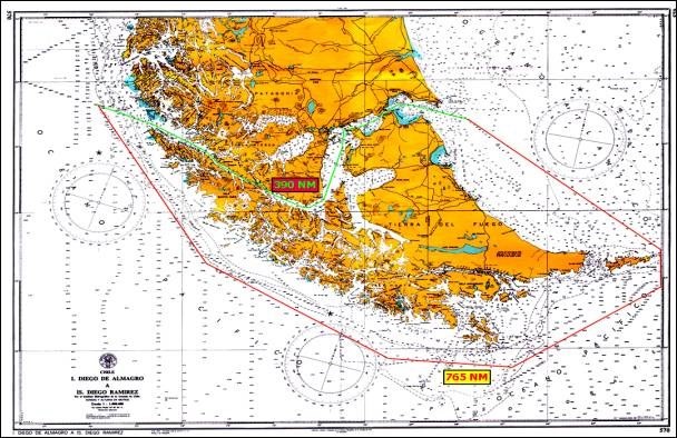
Another interesting point regarding these two routes is that there is a distance of approximately 765 nautical miles for ships navigating from the Atlantic Ocean or vice versa, that decide to cross Paso Drake, going east of Isla de los Estados, considering a point 30 nautical miles to the east of Punta Dungeness to a distance of 30 nautical miles to the west of Islotes Evangelistas.
The distance of that same route through the Strait of Magellan is 390 nautical miles, that is, 375 nautical miles shorter. In other words, 32 more hours of navigation if Cape Horn is the route taken, at an average speed of 12 knots, considering good weather conditions (see chart below).
2. General information on the Strait of Magellan
a) Location and jurisdiction
The Strait of Magellan is a passage located in the southernmost area of South America, among the Chilean Patagonia, Isla Grande de Tierra del Fuego and a large number of islands to the west and towards the Pacific Ocean.
It is the most important natural passage between the Pacific and Atlantic Oceans. The Strait is entirely within Chilean jurisdiction, it is part of the Magellan and Chilean Antarctica Region.
The Chilean-Argentine treaties of 1881 and 1984 ensure its navigation to vessels of all flags at all times and under all circumstances.
b) Length of the Strait of Magellan
The Strait of Magellan, from the eastern entry/exit (Punta Dungeness) to the western entry/exit (Islotes Evangelistas) has a total length of 330 nautical miles. 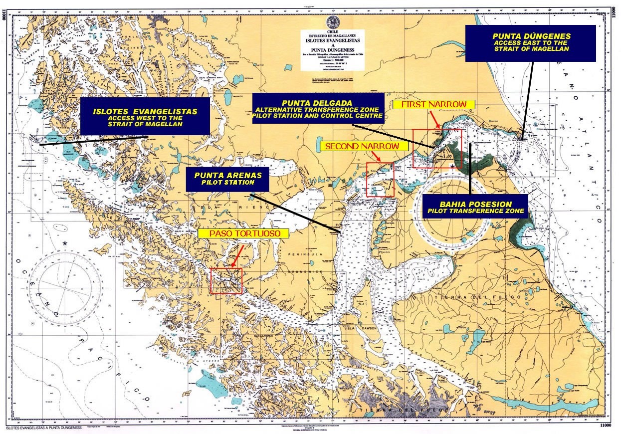
c) General instructions to navigate the Strait of Magellan
- During the voyage through the Strait of Magellan, the International Regulations for Preventing Collisions must be strictly complied with, especially regarding the sound signals established therein.
- Permanently stand by on international VHF safety frequencies, channel 16 and channel 70.
- Inform the Maritime Traffic Control Stations at Faro Islotes Evangelistas, Bahía Félix, Paso Tortuoso, Punta Arenas, Punta Delgada and Punta Dungeness, the entry or exit of the Strait of Magellan, when passing through them.
- Inform the geographical location of the vessel to the National Maritime Authority, according to CHILREP procedure, at 08:00 and 20:00 local time. Vessels navigating without a Channel Pilot between the western entry/exit of the Strait of Magellan and Punta Arenas must do so every 4 hours (see A. - PROVISIONS, REGULATIONS AND GENERAL INFORMATION ON PILOTAGE IN CHILE; 9. - Operational information for Masters; letter g).
- The Maritime Authority will inform when vessels with a length over 200 meters transit the Strait of Magellan, in order to grant them right of way in their navigation.
d) Areas of interest in the Strait of Magellan
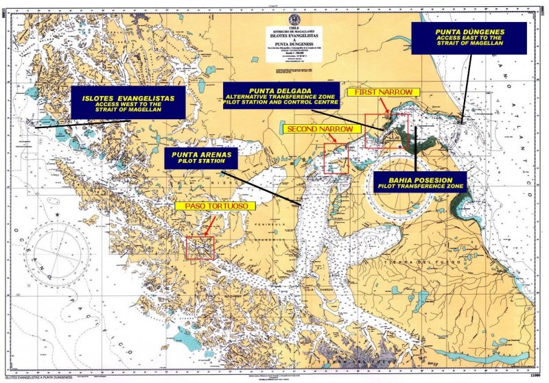
From a navigational point of view, this Strait has basically three areas of interest, the details of which will be given later. These are the First Narrows, the Second Narrows and Paso Tortuoso.
e) Depths and distances in the Strait of Magellan
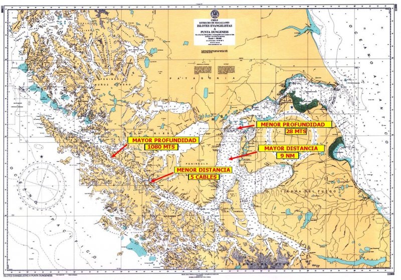
In general, the Strait of Magellan is deep and wide, the shallowest depth on the navigation track is 28 meters in the vicinity of Isla Magdalena and the greatest depth is 1080 meters abeam Faro Cooper Key. In terms of distances, the shortest distance to shore is 5 cables abeam Faro Crosstide, in Paso Tortuoso, and the longest is 9 nautical miles through Puerto Porvenir. The maximum permissible draught to navigate the Strait is 70 feet, or 21.3 meters.
f) Aids to navigation
They are of excellent quality and sufficient to navigate safely at all times, in all its extension. Shoals, no less than 4 cables from the track, are well marked. There are a total of 30 lighthouses and 12 buoys along the entire navigation track, from Punta Dungeness to Islotes Evangelistas. Five of the lighthouses are inhabited by naval personnel and perform maritime traffic control functions (Islotes Evangelistas, Bahía Felix, Islote Fairway, Paso Tortuoso, Punta Delgada and Punta Dungeness).
g) Currents in the Strait of Magellan
Currents in the Strait of Magellan clearly show their effects on the two Narrows and in the Paso Inglés. In the First Narrows, it is where currents have greater intensity throughout the Strait, ranging from 2 knots in periods of low intensity and up to 8 knots in syzygies, both in the flow and ebb current.
h)Tidal amplitude
Tidal amplitudes reach their maximum in the First Narrows, Punta Delgada, since in syzygies there can be up to 8 meters of difference between high and low tide.
i) Hours of light and darkness
In summer (December), there are up to 20 hours of daylight, decreasing in winter (June) to about 6 hours.
j) Presence of ice or icebergs
No presence of ice or iceberg in the Strait, its waters never freeze. This parameter does not affect navigation in any way.
k) Navigation speed through the Strait of Magellan
No speed restrictions in the Strait, which allows navigation at maximum speed throughout all its extension.
l) Anchorages in the Strait of Magellan
In the Strait of Magellan, there are adequate anchorages for all types of vessels. Below, there are details of some of the most appropriate places for anchoring, according to their length.
|
POSITION |
VESSEL LENGHT |
||||||
|
LATITUDE (S) |
LONGITUDE (W) |
CHART |
(+) 150 M |
(-) 150 M |
(-) 100 M |
||
|
PASO TORTUOSO |
1. BAHÍA BORJA |
53° 31.83' |
072° 29.76' |
11311 |
YES |
YES |
YES |
|
PASO INGLÉS |
2. BAHÍA FORTESCUE |
53° 42' |
072° 00' |
11312 |
YES |
YES |
YES |
|
3. BAHÍA CORDES |
53° 43.48' |
071° 55.71' |
11312 |
YES |
YES |
YES |
|
|
4. BAHÍA WOOD |
53° 49.1' |
071° 38.1' |
11432 |
YES |
YES |
YES |
|
|
PASO DEL HAMBRE |
5. BAHÍA SAN NICOLÁS |
53° 50.4' |
071° 06.76' |
11431 |
YES |
YES |
YES |
|
6. PUERTO SAN JUAN DE LA POSESIÓN |
53° 38.21' |
070° 55.61' |
11431 |
YES |
YES |
YES |
|
|
PUNTA ARENAS |
7. PUNTA ARENAS |
53° 10' |
070° 53' |
11410 |
YES |
YES |
YES |
|
SECOND NARROW |
8. BAHÍA FELIPE |
52° 44.34' |
070° 05.89' |
11500 |
YES |
YES |
YES |
Emergency anchorages are non-existent for large-size vessels in the western area of Paso Tortuoso, although anchoring is possible in the vicinity of Bajo Magallanes if extremely necessary, - near Faro Félix. There are better anchorages in the eastern area, such as Pilot Waiting Area in Bahía Posesión, bays Gregorio and Felipe between the First and Second Narrows, Rada de Punta Arenas, and Bahía Fortescue before entering Paso Inglés.
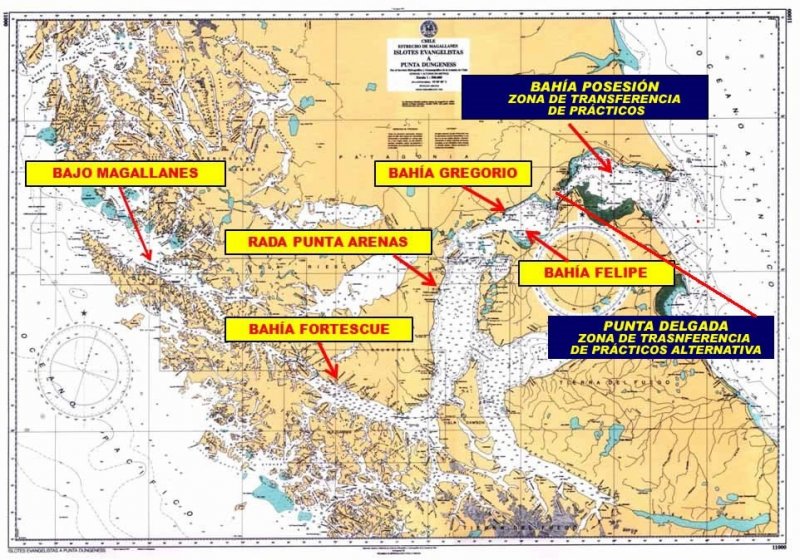
m) Pilot Transfer Zone
Located in Bahía Posesión (Lat. 52°22.75 S, Long. 068°58.63 W) in the vicinity of the platforms line, 19 nautical miles from Faro Punta Delgada Pilot Station and 22 nautical miles from Faro Punta Dungeness. In case of bad weather that makes it difficult to embark pilots at the Transfer Zone, there is a waiting area where vessels can anchor at 30 meters’ deep. As an alternative, vessels can keep navigating alone to or from Punta Delgada (Lat. 52°28.17 S, Long. 069°31.43 W), with the pilot assistance from the Pilot Station control room, where there is a state-of-the-art radar with S-57 chart management, AIS and ARPA display. It has all the capabilities of a basic VTS.
n) Security Messages during transit
When large-size vessels with a length over 200 meters enter the Strait of Magellan, the National Maritime Authority sends a Security message, broadcasted on VHF Channel 16 across all the inhabited lighthouses. This message is repeated while the vessel navigates through the Strait of Magellan, stipulating right of way.
o) Tug boats
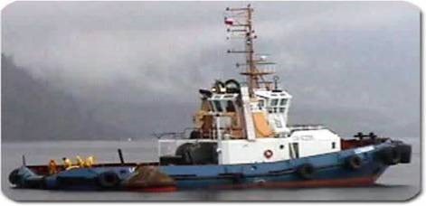
Eight High Seas tug boats operate from Punta Arenas. Their bollard pull is about 65 tons, with engine power from 2000 HP to 5000 HP. They can quickly assist vessels requiring their service.
3. First narrows
The First Narrows has an extension of 8 nautical miles from Punta Delgada to Bajo Satélite. It is a straight passage with a mean width of 2 nautical miles in its narrow section and the mostly affected area of the Strait of Magellan by currents and tides. As explained above in syzygies, the current may reach an intensity of 8 knots and a tide amplitude of 8 meters.
Current is oriented towards the Strait of Magellan direction, increasing or decreasing the vessel speed without significantly affecting its course.
The most significant danger is in Bajo Satélite, located 1 nautical mile north of the navigation track, in the south of the passage.
In the eastern entry, there is a ferry crossing area, where normally 2 of these vessels operate 24 hours a day. Vessels navigating throughout the Strait have the right of way, and the masters of these ferries are familiarized in this regard, so they are not a danger for navigation.
4. Second narrows
The Second Narrows has an extension of 12 nautical miles from Cabo Gregorio in the north to Cabo San Vicente in the south. Its narrowest part is of 4 nautical miles abeam promontory Sweepstakes.
As well as in the First Narrows, current is oriented towards the narrows direction, increasing or decreasing the vessel speed without mostly affecting its course. Its maximum intensity reaches 6 knots in syzygies.
In this narrows, while navigating from east to west with current in favour, there must be caution and lookout when changing course for entering Paso Nuevo, from Cabo San Vicente to Isla Magdalena. This is because the current tends to get the vessel off course in the direction of banco Santa Marta. Reaction is possible without difficulties, as Santa Marta is 4 nautical miles west of the navigation track, which gives sufficient area for manoeuvring.
5. Paso Tortuoso
The total extension of this passage, between Punta San Jerónimo and Cabo Quod, is 6.3 nautical miles, with its greatest useful width being 0.9 nautical miles between Cabo Crosstide and Roca Anson.
In this passage, the north coast has two shoals properly marked by buoys. These are Roca Anson and Roca Crooked, which are located 4 cables to the north of the navigation track.
The difficulty of this passage is represented by the crosscurrents, which go up or down Canal Jerónimo, and affect the vessel transversely up until the entry or exit of Paso Inglés, near Isla Rupert. In the proximity of Cabo Crosstide, as well as in Paso Inglés, the currents reach up to 3.5 knots and sometimes more during ebb tide. This is due to the fact that in this area the current of the Strait of Magellan meets the current of Canal Jerónimo. In general, the current feels more intensely in the direction of the prevailing winds, that is, from NW to SE.
Vessels with great draught and length can wait for the slack current to occur in Canal Jerónimo, in order to navigate Paso Tortuoso with more tranquility and safety. The experience of the Channel Pilots currently makes it possible to navigate this passage with large vessels, up to 21.3 m draught, at any time.
Special instructions for the navigation of Paso Tortuoso:
Considering that vessels’ size has increased considerably, making it difficult for them to maneuver quickly in order to comply with the International Regulations for Preventing Collisions at Sea while crossing Paso Tortuoso, it is arranged to:
a) Inform the corresponding Maritime Traffic Control Station (Faro Evangelistas, Bahía Félix, Punta Arenas or Punta Delgada) of the estimated passing time through Paso Tortuoso. When a Channel Pilot is on board, they perform this assignment.
b) In the passage itself, there is the Maritime Traffic Control Station “Tortuoso”, which should be called to report navigation in the area and to report the next control points in the Strait of Magellan towards the vessel's destination. When a Channel Pilots are on board, they perform this task.
c) Permanently stand by on the international VHF safety frequencies, Channel 16 and Channel 70. On channel 16, broadcast a safety message, in Spanish and then in English, one hour before crossing Cabo Crosstide, informing: vessel's name, current position, crossing direction and estimated time of crossing. This same information shall be repeated every 15 minutes until the end of the crossing.
d) Navigate to starboard of the channel axis, whenever possible and without affecting the safety of the vessel.
e) Grant right of way to the transit of VLCC type super vessels, or vessels with a length over 200 m, informed by safety signals from the National Maritime Authority or reported by the Maritime Traffic Control Stations in the Strait of Magellan.
f) Keep the navigation lights permanently on.
6. Specific characteristics of the western area of the Strait of Magellan (from Cabo Pilar to Cabo Froward)
The bad weather conditions prevailing in the South Pacific have made it a common practice for almost all ships to navigate the western channels of Patagonia, which are conveniently marked with lighthouses, beacons and luminous buoys to allow night-time navigation with the required safety (see C.- "NAVIGATION ROUTES IN CHILEAN CHANNELS, STRAITS AND FJORDS (Chacao Channel to Cape Horn)".
a) Winds : The general regime in this area is of an overcast sky, both at night and during the day. The storms of the Southeast Pacific are also felt inside the Strait, although with less intensity than in the open sea, with gusty wind and without significant waves. The wind, whether its main direction is NW or SW, will be received by the navigator in all directions within the 3rd and 4th quadrant, depending on the orientation of the creeks that will be faced.
b) Tides and currents : The tidal range in the western region of the Strait of Magellan rarely exceeds 2 m and the intensity of the currents is generally negligible, at least for ships of medium engine power. The only place to watch out for is Paso Tortuoso near Cabo Crosstide.The current near Cabo Pilar takes the direction of the Strait of Magellan at its estuary, meaning, a general SE direction, which makes a ship drift on the S coast of this strait. This current in calm and smooth sea conditions has an intensity between 0.5 and 1 knot. The ocean current increases when it meets the flow current. Both currents shall be considered by the navigator who, for a safer track, must calculate the tide in order to know its influence on the advance and/or leeway of the vessel.
c) Anchorages:The extent of anchorages in the western region of the Strait of Magellan is generally very limited. It should be noted that the anchorages indicated on nautical charts with the relevant symbol are a recommendation based on experience. The navigator will select the appropriate anchorage taking into consideration the size and draught of the vessel, the existing depths and the available swinging space (see B.- NAVIGATION IN THE STRAIT OF MAGELLAN, 2.- GENERAL INFORMATION ON THE STRAIT OF MAGELLAN; l) Anchorages in the Strait of Magellan).
d) Prevention During night-time navigation through the Strait of Magellan, caution should be taken with water or snow showers that produce closures that prevent the lighthouses and the coast from being seen. Particularly in this regard are Paso Largo, Paso Tortuoso and Paso Inglés where extreme precautions must be taken to prevent the vessel to go off course leading to risky situations.
Navigation through channels, straits and fjords in Chiloé, Patagonia and Tierra del Fuego
1. General information on the compulsory pilotage area
For navigating from Chacao Channel to Cape Horn (see Figure 1: General chart of the Compulsory Pilotage Area) there are two navigation routes, one oceanic, which does not require further explanation, and the other one through channels and inland waters. The channel route offers different alternatives and is highly recommended in case of bad weather conditions, which are common in this area. Likewise, it gives the opportunity to see places of unique natural beauty, such as glaciers, waterfalls, inlets, and to appreciate the existing marine flora and fauna.
All routes through Chilean channels, straits and fjords are signaled; they present no major difficulties for navigation and have updated nautical charts, both paper and electronic. The Hydrographic and Oceanographic Service of the Chilean Navy, www.shoa.cl, a body that is part of the International Maritime Organization, edits and updates national charts used in the navigation of Chilean channels, straits and fjords.
With the purpose of providing safety to navigation and coordinating vessel traffic, the National Maritime Authority has established transit provisions for the crossing of certain channels, schedules and general recommendations (see A.- PROVISIONS, REGULATIONS AND GENERAL INFORMATION ON PILOTAGE IN CHILE. 9. Operational information for Masters; b) Special restrictions for the following channels, straits and narrows). In addition to the above restrictions, the Ancud Transfer Zone has the following restriction for the embarkation and disembarkation of pilots:
|
LIMIT PARAMETERS FOR MANEUVERS |
||||
|
Maneuver |
Max. length |
Max. draught |
Douglas |
Beaufort |
|
Embarkation |
230 m |
11 m |
3 (1.25 m) |
6 (22 - 27 kn) |
|
Disembarkation |
230 m |
11 m |
3 (1.25 m) |
6 (22 - 27 kn) |
There are vessels that shall carry out pilot transfer maneuvers in the Laitec area because their special maneuverability characteristics are different from any other type of vessel, such as large deadwork exposed to the wind and their bottom exposed to the current, make them unsuitable for navigation in winding channels with intense currents, such as Chacao Channel and surrounding areas.
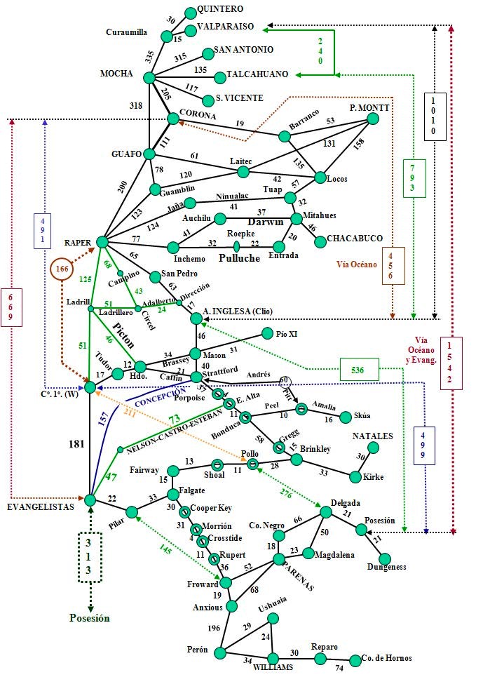
2. Southbound alternative routes
a) For ships with a length up to 180 m and a draught up to 10.7 m (Restriction for Angostura Inglesa)
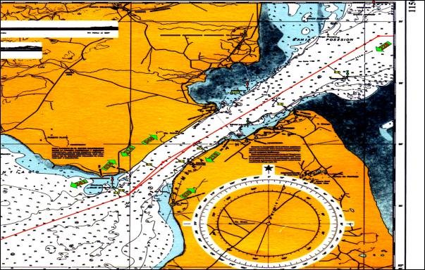
- These vessels can safely transit the whole route of channels in the Chiloé area, from Chacao Channel to Canal Darwin, which has an extension of 282 nautical miles (see Figure No. 2).
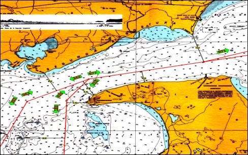
- Vessels with a length up to 180 m can also use the route of Patagonian channels, from Canal Messier (Faro San Pedro) via Angostura Inglesa, continuing through Angostura Guía, Paso Summer/Canal Gray, and Paso Shoal to the Strait of Magellan; or alternatively, through Canal Fallos (Faro Campino), Canal Trinidad, Angostura Guía, Paso Summer/Canal Gray and Paso Shoal. This route has an extension of 358 nautical miles via Canal Messier, and 382 nautical miles via Canal Fallos (see Figure No. 3).
- To sum up, vessels with a length up to 180 m and a draught up to 10.7 m can navigate 640 nautical miles through channels.
b) For ships with a length up to 230 m and a draught up to 12 m (Restriction for Canal Gray)
- These vessels can safely use the whole route of channels in the Chiloé area, from Chacao Channel to Darwin Channel, with an extension of 282 nautical miles (see Figure No. 2)
- Likewise, they can use the route of Patagonian channels, from Canal Fallos (Faro Campino) to the Strait of Magellan via Canal Trinidad, Angostura Guía, Canal Gray and Paso Shoal; a total extension of 382 nautical miles and 331 nautical miles through channels (see Figure No. 3).
- The alternative to avoid waiting until daylight for navigating Canal Gray is to exit to the ocean and enter the Strait of Magellan by Canal Esteban, Canal Castro and Estrecho Nelson. This implies navigating 163 nautical miles through channels and 47 nautical miles through ocean.
b) For ships with a length over 230 m and a draught over 12 m
- These vessels can safely navigate the whole route of channels in the Chiloé area, from Chacao Channel to Canal Ninualac or Canal Darwin, with an extension of 259 nautical miles via Canal Ninualac (see Figure No. 2).
- In the route of Patagonian channels, vessels can navigate from Canal Fallos (Faro Campino) to the Strait of Magellan via Canal Trinidad, Canal Inocentes, Angostura Guía, Canal Esteban, Canal Castro and Estrecho Nelson; an extension of 304 nautical mile, of which 253 are through channels. In case of currents and strong winds in the Angostura Guía area, it is possible to navigate Canal Andrés and Pitt (see Figure No. 3).
- It is worth mentioning that Supertankers and passenger vessels with a length of approximately 300 m usually navigate the latter route.
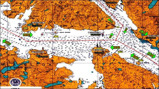
d) Route of Fuegian channels to Cape Horn
- All vessels can transit the route of the Fuegian channels from the Strait of Magellan through channels Magdalena, Cockburn, Unión, Ballenero, O’Brien, northwest area of Beagle Channel and the Beagle Channel up to Cape Horn (see figure No. 4).
- Fuegian channels, which have numerous glaciers in the northwest and southwest area of Beagle Channel, constitute the main route to reach Cape Horn and Antarctica through inland waters.
- The following figures provide the description of the different alternative routes through the Chilean channels, straits and fjords:
|
Figure 2 |
It shows the routes of channels in the Chiloé area, from Chacao Channel to Golfo de Penas. |
|
Figure 3 |
It shows the routes of Patagonian channels, from Golfo de Penas to the Strait of Magellan. |
|
Figure 4 |
It shows the routes of the Fuegian channels, from the Strait of Magellan to Cape Horn. |
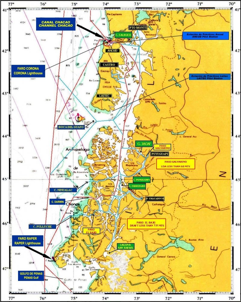 Figure 2
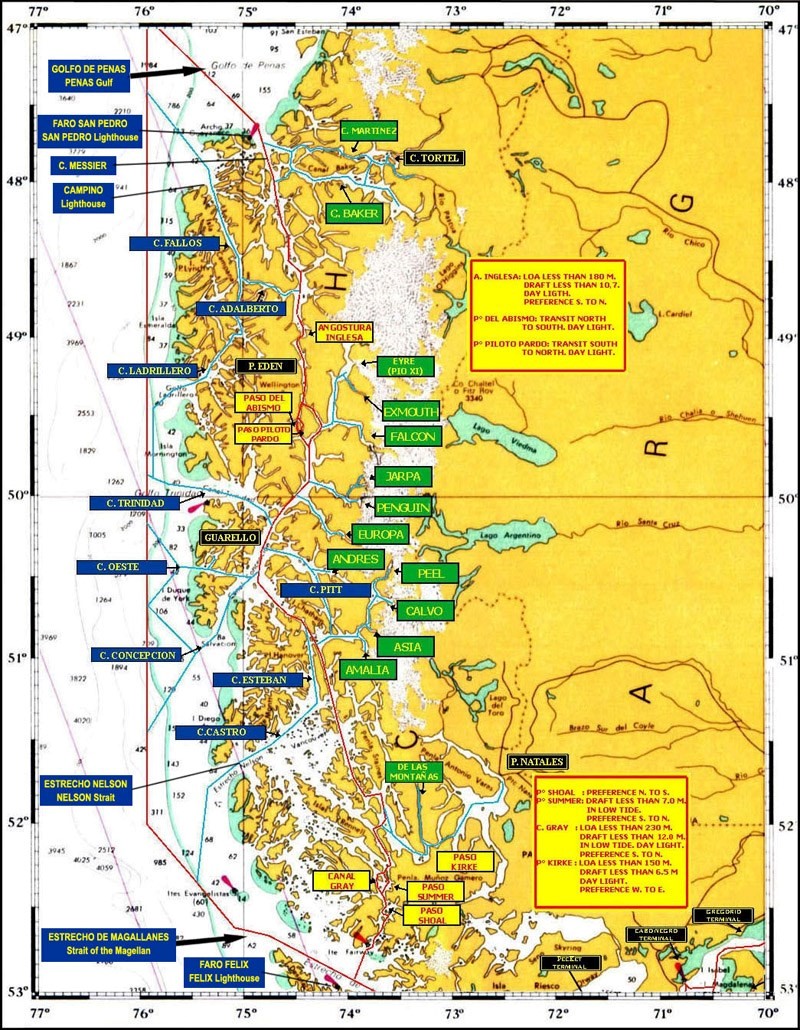
Figure 3
3. Distance graph