Usted está en:
2. Southbound alternative routes
a) For ships with a length up to 180 m and a draught up to 10.7 m (Restriction for Angostura Inglesa)
- These vessels can safely transit the whole route of channels in the Chiloé area, from Chacao Channel to Canal Darwin, which has an extension of 282 nautical miles (see Figure No. 2).
- Vessels with a length up to 180 m can also use the route of Patagonian channels, from Canal Messier (Faro San Pedro) via Angostura Inglesa, continuing through Angostura Guía, Paso Summer/Canal Gray, and Paso Shoal to the Strait of Magellan; or alternatively, through Canal Fallos (Faro Campino), Canal Trinidad, Angostura Guía, Paso Summer/Canal Gray and Paso Shoal. This route has an extension of 358 nautical miles via Canal Messier, and 382 nautical miles via Canal Fallos (see Figure No. 3).
- To sum up, vessels with a length up to 180 m and a draught up to 10.7 m can navigate 640 nautical miles through channels.
b) For ships with a length up to 230 m and a draught up to 12 m (Restriction for Canal Gray)
- These vessels can safely use the whole route of channels in the Chiloé area, from Chacao Channel to Darwin Channel, with an extension of 282 nautical miles (see Figure No. 2)
- Likewise, they can use the route of Patagonian channels, from Canal Fallos (Faro Campino) to the Strait of Magellan via Canal Trinidad, Angostura Guía, Canal Gray and Paso Shoal; a total extension of 382 nautical miles and 331 nautical miles through channels (see Figure No. 3).
- The alternative to avoid waiting until daylight for navigating Canal Gray is to exit to the ocean and enter the Strait of Magellan by Canal Esteban, Canal Castro and Estrecho Nelson. This implies navigating 163 nautical miles through channels and 47 nautical miles through ocean.
b) For ships with a length over 230 m and a draught over 12 m
- These vessels can safely navigate the whole route of channels in the Chiloé area, from Chacao Channel to Canal Ninualac or Canal Darwin, with an extension of 259 nautical miles via Canal Ninualac (see Figure No. 2).
- In the route of Patagonian channels, vessels can navigate from Canal Fallos (Faro Campino) to the Strait of Magellan via Canal Trinidad, Canal Inocentes, Angostura Guía, Canal Esteban, Canal Castro and Estrecho Nelson; an extension of 304 nautical mile, of which 253 are through channels. In case of currents and strong winds in the Angostura Guía area, it is possible to navigate Canal Andrés and Pitt (see Figure No. 3).
- It is worth mentioning that Supertankers and passenger vessels with a length of approximately 300 m usually navigate the latter route.
d) Route of Fuegian channels to Cape Horn
- All vessels can transit the route of the Fuegian channels from the Strait of Magellan through channels Magdalena, Cockburn, Unión, Ballenero, O’Brien, northwest area of Beagle Channel and the Beagle Channel up to Cape Horn (see figure No. 4).
- Fuegian channels, which have numerous glaciers in the northwest and southwest area of Beagle Channel, constitute the main route to reach Cape Horn and Antarctica through inland waters.
- The following figures provide the description of the different alternative routes through the Chilean channels, straits and fjords:
|
Figure 2 |
It shows the routes of channels in the Chiloé area, from Chacao Channel to Golfo de Penas. |
|
Figure 3 |
It shows the routes of Patagonian channels, from Golfo de Penas to the Strait of Magellan. |
|
Figure 4 |
It shows the routes of the Fuegian channels, from the Strait of Magellan to Cape Horn. |
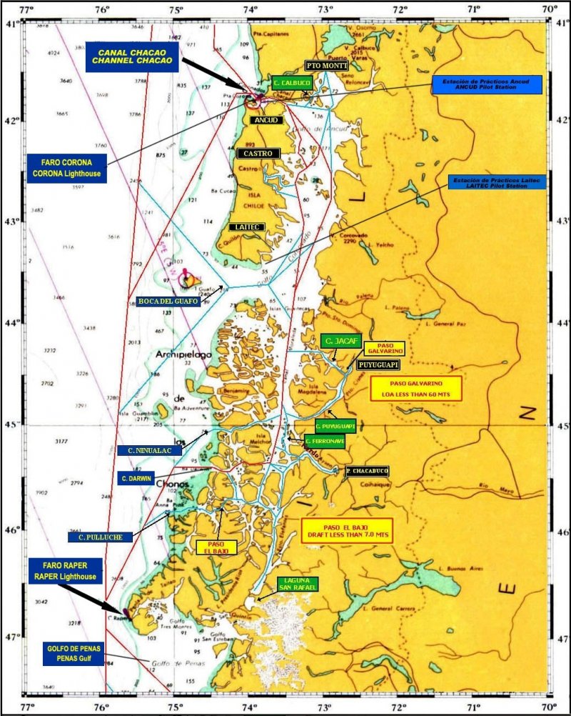 Figure 2
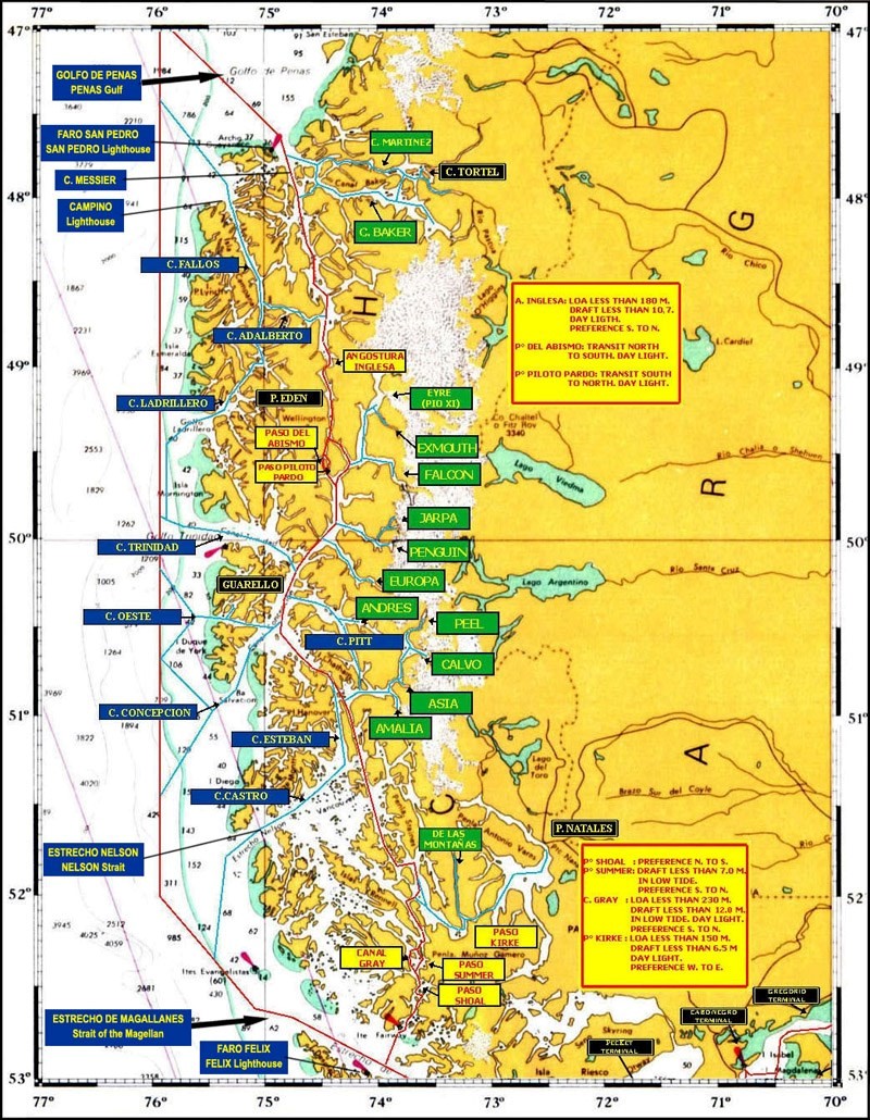
Figure 3